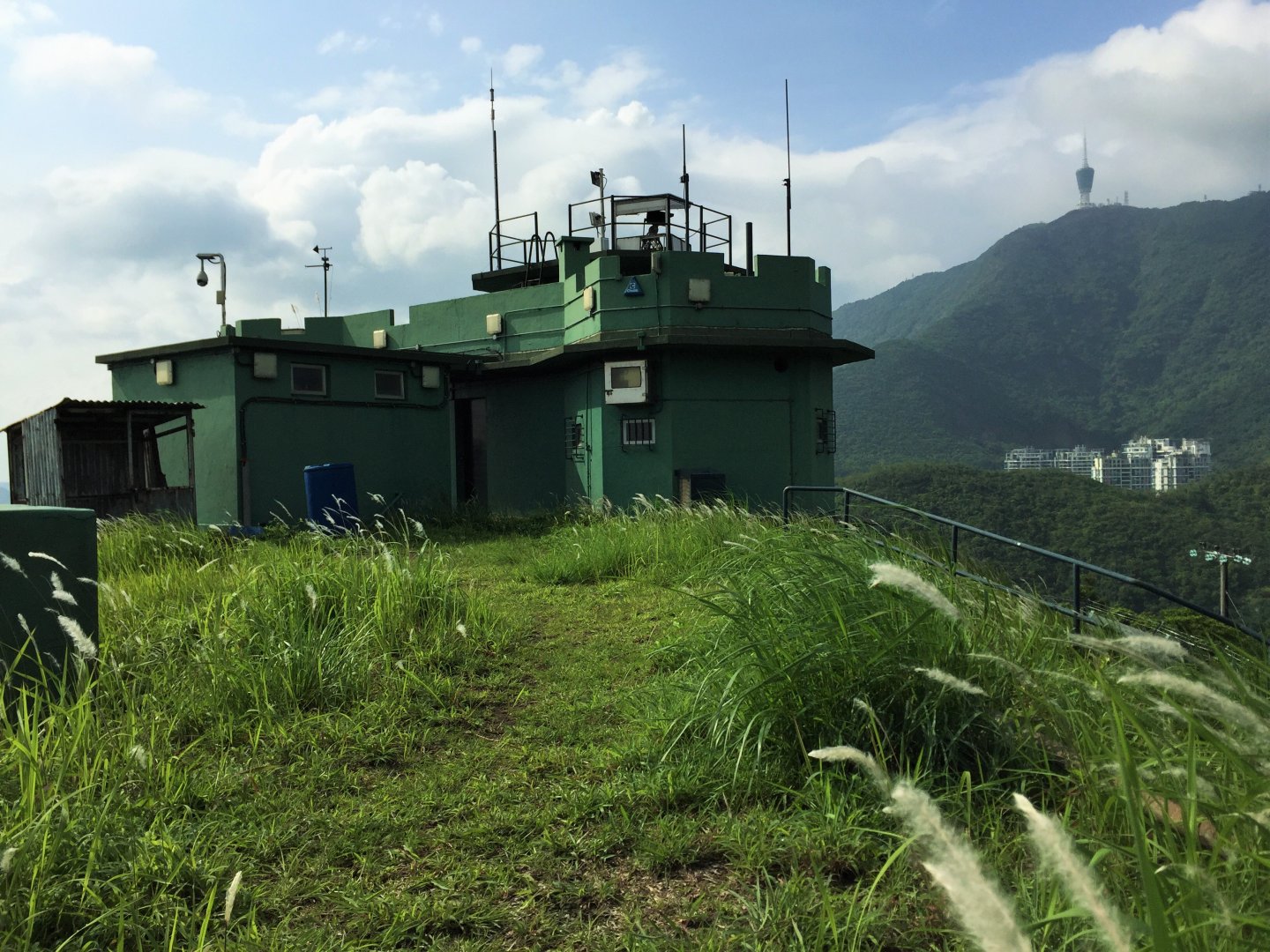
MacIntosh Forts (Kong Shan)
With the authorities lifting restrictions on access to Hong Kong's northern borderlands, former colonial-era military spots in the erstwhile forbidden zone are finally off bounds no more. The MacIntosh Forts, considered the bastion of the city's “frontline” for over half of a century, has never long fallen off the public records – and consciousness – until 2012.These heritage sites, along with the grasslands and graveyards around them in this previously closed-off area, are now slowly becoming new attractions to local tourists.
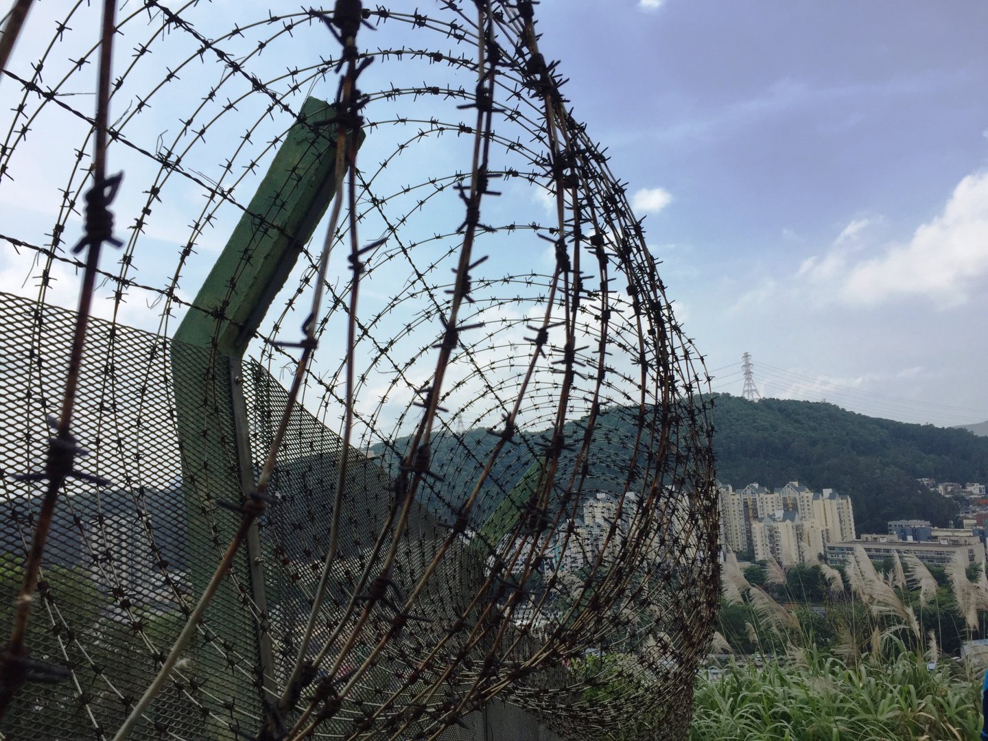
This “new” zone has been rarely explored due to limited public access down the years. But this newly returned freedom of access rings in as much risks as opportunities, as these untarnished lands become prime targets for property developers eyeing their next gated condo-complex. The question remains: how should we keep these pastures free from the shackles of so-called development?
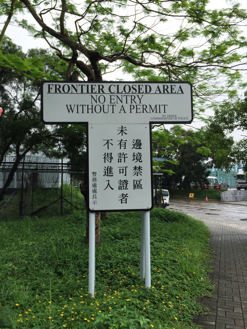
Road sign at the new frontier
The extent of what was officially known as the Frontier Closed Area (FCA) has been reduced in three stages during the last four years. The first stage, implemented in 2012, covered the section between Mai Po and the Lok Ma Chau Boundary Control Point, and the tracts between Sha Tau Kok and Lin Ma Hang. A year onwards, the second stage released the lands between the Lok Ma Chau Boundary Control Point and the Ng Tung River. The final stage, which came to pass in early 2016, lifted restrictions to public access to areas lying between the Ng Tung River and Lin Ma Hang.
Hikers and local tourists have been particularly drawn to the possibilities emerging out of the FCA reduction scheme, and have since raced to visit these former political twilight zones. Among them, the MacIntosh Forts remain high on their checklists. The forts, named after the then police commissioner D.W. MacIntosh, were built to oversee and secure the border from illegal immigrants. There are 7 forts in total, all of the same style and of similar design, built along the frontier between 1949 and 1953. Border patrols and supervision took place day and night.
These military heritage sites, along with the village buildings, lead mines and the natural landscapes they sit on, have been well-preserved throughout the past few decades – simply because they are not within easy reach. This pristine state of things is very vulnerable to an increase in human footprint: visitors are advised to help protecting the environment by leaving as little trace of their presence as possible.
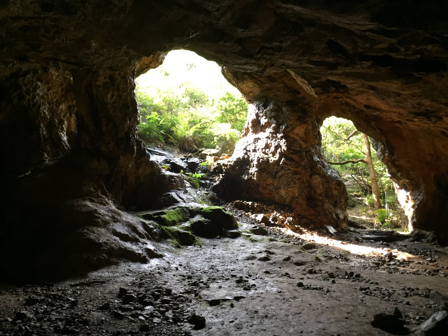
Lin Ma Hang Lead Mine
Mining the past: between Sha Tau Kok and Lin Ma Hang
This is the earliest released area in the FCA, but the least accessible for most visitors, who will find it difficult to identify the roads and footpaths in the middle of blooming forests and bushes. It poses a threat for the under-prepared, even if one is a regular hiker.
Still, those who come and manage to find the lead mines would find all their efforts worthwhile. These quarries, located at Lin Ma Hang, are famous for the peculiar sights in them. The sound of water beating against rocks in the mine's vast spaces is like music played out in the best acoustics. The unique ventilation system cools you down immediately regardless of the heat wave outside. Nevertheless, danger lurks within this labyrinth of caves: don't venture too far inside.
Beyond the tranquility lies remnants of war – now transformed from artificial relics to a natural habitat. The WWII-era trenches and pillboxes in the area remain in a very good condition, and have since become a home to bats and all kinds of reptiles. Mosquitoes, meanwhile, are rampant here. While fauna flourishes, humans will find it hard to survive in such harsh living condition.
Therefore, it is unimaginable how trespassers could navigate this area without a map, a light and mobile GPS devices which, of course, have only become readily available during the past decade. It is believed a sizeable number of these unfortunate and desperate itinerants died and were buried in unmarked graves nearby.
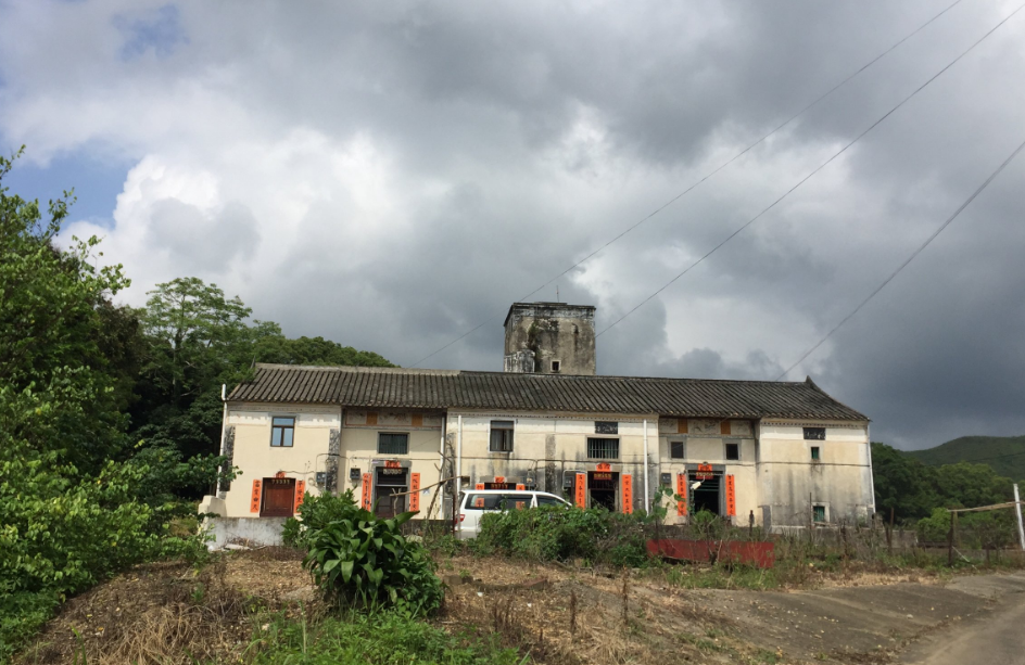
Village hourse and a four-storey watchtower at Heung Yuen Wai
Bastions, manors… and a bus: between Ng Tung River and Lin Ma Hang
A wide variety of heritage sites dot the landscape in this area, including three of the seven MacIntosh forts. The Pak Fu Shan outpost, at Heung Yuen Wai, can be accessed directly by car. The Ngau Yiu site in Ta Kwu Ling, is slightly more challenging, but visitors can also visit a traditional kiln nearby. The fort at Nam Hang, in Man Kam To, is a good spot to survey the Shenzhen River and the bustling cityscape across the border. The curious and bold might want to drop by the communal graves at Sandy Ridge Cemetery to visit the nameless plaques there.
Apart from these forts, this area also boasts of non-military buildings and architectural relics. Heung Yuen Wai, a settlement established more than three centuries ago, is famous for its well-preserved village houses and a four-storey watchtower. Time is made to stand still next to this old-school skyscraper, with a connecting house containing decor and furniture which has remained unchanged for more than 80 years. There's a photo on the wall of a man in a tuxedo – most likely a portrait of the original owner who probably paid for the construction of these buildings – as well as an improved and more secure livelihood for his clan – through the money he earned overseas.
And then there are the grasslands which have remained undiscovered until now – a picturesque landscape with various shades of green glistering in the sun, and fields of miscanthus swaying in the wind.
Amidst such pastoral beauty, a surprise beckons when you walk from Sun Uk Ling to Sandy Ridge: a disused bus stranded in the middle of the countryside. Why it's there is anybody's guess: it's probably relieved from service in the late 1990s, but nobody could confidently say why it ended up in a field. Not that it matters for bus geeks, who have been eagerly awaiting the opening of the FCA to take a snap of the vehicle.
A new frontline: Illusions and confusions at the borderlands
Walking through the former FCA, one gets to experience what it was like for illegal immigrants from all those years ago: it's all about struggling to venture forward through the dense undergrowth, when well-paved roads are just a short distance away, out of reach because of the heavily guarded barriers outside and within the forbidden zone.
Standing on this frontier between mainland China and Hong Kong, it's interesting to note how different the landscapes are. Over there, high-rises flaunt boom and prosperity; over here, wild nature with its hills, trees, scattered villages and abandoned buildings and border fortifications.
But this wilderness does not equate backwardness. Rather, beauty and vitality lies in these untouched lands, qualities in peril when entrepreneurs arrive banging the drums of so-called development: a threat which is very real as the lifting of the FCA releases land for purchase and speculation. As a new boundary control point is put together near Heung Yuen Wai, advertisements also sprouts around the area, inviting local residents to sell up for the right price. Maybe that's the new, real frontline: a battle for the spirit and soul of Hong Kong's natural landscapes.
_________________________________________
Routes:
Mining the Past: betweenSha Tau Kok and Lin Ma Hang
Wide varitey of heritage sites in Heung Yuen Wai and Man Kam To